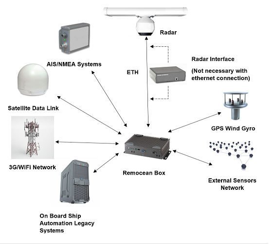
The Remocean Coastal Surveillance system allows, thanks to the use of powerful algorithms for the analysis of radar data , to detect and trackreflective targets on the sea surface . The integration of the traces provided by the analysis of the radar signal with those received by an AIS system allows to carry out the control and surveillance of the area swept by the radar at a maximum distance of 24 NM from the radar antenna. The integrated use of a radar and an AIS device allows, in fact, to detect and identify , in the case of cooperating targets (which transmit AIS information), and of detect and track non-cooperating mobile targets (which do not transmit AIS information) thus providing a complete framework for control and surveillance of the area of interest.
Integration with drones and cameras
The Remocean Coastal Surveillance System can be integrated with surveillance cameras and drones . The integration module between the Remocean Coastal Surveillance system and the camera allows, if foreseen in the system configuration, to automatically point the view towards a specific objective in order to identify the objectives more effectively.
Technical specifications
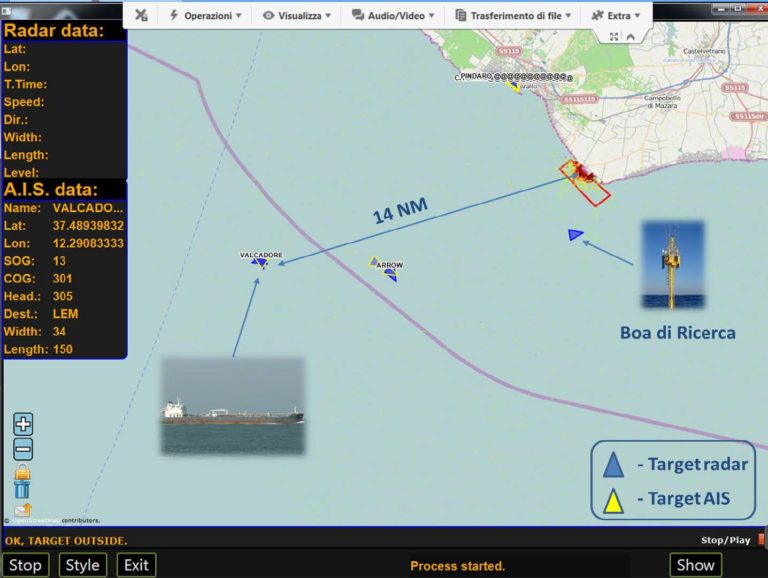
The system of Coastal Surveillance of Remocean is equipped with an interactive user interface that allows you to draw polygonal areas (red polygon in the figure below) within which you want to concentrate the control and surveillance activity as happens, for example in the case of marine protected areas, in general, in the case of areas restricted to navigation. In this way it is possible to: • generate alarms when one or more targets enter or leave a specific area; • generate alarms when one or more targets exceed a virtual limit; • generate alarms when one or more targets exceed a certain speed limit in an area (or in the entire radar scan); • count the number of targets entering / exiting a specific area.
All the information of both the radar and AIS targets that are inside the polygon are recorded in the database so that the history of the single target and its identification , if possible, can be subsequently traced.
Remocean Coastal Surveillance System user interface